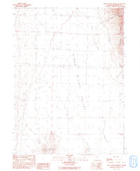
1991 Map of Sheep Ranch Springs
USGS Topo · Published 1991About this map
Kings River Valley serves as the central corridor of this arid Nevada landscape, where the Kings River flows south between the Montana Mountains to the east and the Coyote Hills at the southern edge. The map reveals a land managed for water and resource extraction, characterized by a network of wells, reservoirs, and stock ponds scattered across the basin. Human presence is sparse but specific, including a Trailer Park near the valley center and a Transmission Line cutting across the northern reaches. Evidence of small-scale industry appears on the eastern slopes of the mountains, where a Prospect and Borrow Pit are located near Thacker Creek. The northeast corner is anchored by Sheep Ranch Springs, a critical water source in this high-desert environment.
Find a feature on this map
16 named features on this map. Tap any name to fly to it.
Don’t see what you’re looking for? This feature index may not catch every label — zoom into the map to look around manually.
Map Details
Editions of this 1991 Sheep Ranch Springs Map
This is the sole edition of this map. No revisions or reprints were ever made.
Other maps of this area

1886 · Disaster
USGS Topo · 1:250,000

1893 · Disaster
USGS Topo · 1:250,000

1954 · Vya
USGS Topo · 1:250,000

1958 · Vya
USGS Topo · 1:250,000

1961 · Quinn River Crossing
USGS Topo · 1:62,500

1961 · Thacker Pass
USGS Topo · 1:62,500

1961 · Trident Peak
USGS Topo · 1:62,500

1961 · Disaster Peak
USGS Topo · 1:62,500

1962 · Vya
USGS Topo · 1:250,000

1979 · Denio
USGS Topo · 1:100,000