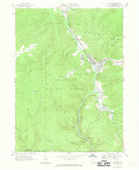
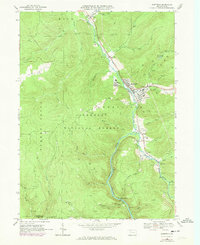
1966 Map of Sheffield
USGS Topo · Published 1969About this map
South Branch Tionesta Creek winds through a landscape defined by timber and natural gas extraction in the late 1960s. Much of the western terrain is protected within the Allegheny National Forest, where steep ridges like Bull Hill are dissected by narrow drainages including Arnot Run and Lacey Run. The valley bottoms serve as the primary corridors for settlement and industry, following the Penn Central railroad line through the community of Sheffield and smaller outposts like Saybrook and Tiona.
Find a feature on this map
48 named features on this map. Tap any name to fly to it.
Don’t see what you’re looking for? This feature index may not catch every label — zoom into the map to look around manually.
Map Details
Editions of this 1966 Sheffield Map
2 editions found
Other maps of this area

1906 · Warren
USGS Topo · 1:62,500

1907 · Warren
USGS Topo · 1:62,500

1908 · Warren
USGS Topo · 1:62,500

1934 · Kane
USGS Topo · 1:48,000

1935 · Sheffield
USGS Topo · 1:48,000

1936 · Kinzua
USGS Topo · 1:48,000

1939 · Kane
USGS Topo · 1:62,500

1941 · Sheffield
USGS Topo · 1:62,500

1941 · Kinzua
USGS Topo · 1:62,500

1947 · Cherry Grove
USGS Topo · 1:24,000
Featured Places
- Sheffield Township, PA
- Cherry Grove Township, PA
- Hoover, Sheffield Township
- Howe Township, PA
- Mead Township, PA