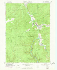
1966 Map of Sheffield
USGS Topo · Published 1973About this map
Allegheny National Forest dominates the landscape of this 1966 survey, where the timbered hills of Warren County are etched by a dense network of industrial activity. The confluence of the West Branch Tionesta Creek and Tionesta Creek serves as the geographic heart of the region, anchoring the town of Sheffield and the nearby settlement of Barnes. This area reveals a land defined by petroleum extraction, with hundreds of Oil Wells and Gas Wells scattered across the ridges, particularly around Saybrook and the upper reaches of Arnot Run.
Find a feature on this map
50 named features on this map. Tap any name to fly to it.
Don’t see what you’re looking for? This feature index may not catch every label — zoom into the map to look around manually.
Map Details
Editions of this 1966 Sheffield Map
2 editions found
Other maps of this area

1906 · Warren
USGS Topo · 1:62,500

1907 · Warren
USGS Topo · 1:62,500

1908 · Warren
USGS Topo · 1:62,500

1934 · Kane
USGS Topo · 1:48,000

1935 · Sheffield
USGS Topo · 1:48,000

1936 · Kinzua
USGS Topo · 1:48,000

1939 · Kane
USGS Topo · 1:62,500

1941 · Sheffield
USGS Topo · 1:62,500

1941 · Kinzua
USGS Topo · 1:62,500

1947 · Cherry Grove
USGS Topo · 1:24,000