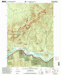
1995 Map of Shelburne
USGS Topo · Published 2001About this map
The Androscoggin River winds through this New Hampshire and Maine borderland, providing the central valley around which the community of Shelburne is oriented. During the mid-1990s, the landscape was defined by the intersection of forest management and backcountry recreation, with extensive coverage of the White Mountain National Forest and Leadmine State Forest. The map documents a rugged network of high-altitude routes including the Appalachian Scenic Trail and Mahoosuc Trail, which connect peaks like Mount Success and North Bald Cap. Genealogists and local historians can locate the Hazelton Cem and other burial grounds near the river, while the presence of the Keene Reservoir and Pipelines indicates the infrastructure supporting the region's utility and water management. Shelters like Gentian Shelter and Carlo Col Shelter mark the established camps for long-distance hikers traversing the Mahoosuc Range.
Find a feature on this map
75 named features on this map. Tap any name to fly to it.
Don’t see what you’re looking for? This feature index may not catch every label — zoom into the map to look around manually.
Map Details
Editions of this 1995 Shelburne Map
This is the sole edition of this map. No revisions or reprints were ever made.
Other maps of this area

1893 · Gorham
USGS Topo · 1:62,500

1896 · Gorham
USGS Topo · 1:62,500

1914 · Bethel
USGS Topo · 1:62,500

1930 · Milan
USGS Topo · 1:62,500

1933 · Milan
USGS Topo · 1:62,500

1934 · Milan
USGS Topo · 1:62,500

1937 · Gorham
USGS Topo · 1:48,000

1940 · Bethel
USGS Topo · 1:62,500

1941 · Bethel
USGS Topo · 1:62,500

1942 · Gorham
USGS Topo · 1:62,500