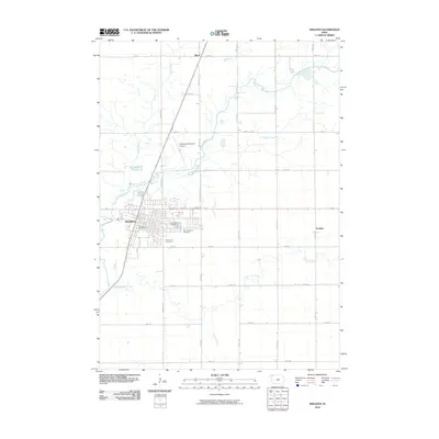
2010 Map of Sheldon
USGS Topo · Published 2010About this map
The Floyd River and its tributary, the Little Floyd River, define the agricultural landscape of this O'Brien County region. Centered on the city of Sheldon, the map reveals a well-organized grid of rural roads and sections typical of Northwest Iowa. Local history and genealogy interests are well-represented by several burial grounds situated on the outskirts of the main settlement, including East Lawn Cemetery, Saint Patricks Cemetery, and Saint Paul Cemetery.
Find a feature on this map
29 named features on this map. Tap any name to fly to it.
Don’t see what you’re looking for? This feature index may not catch every label — zoom into the map to look around manually.
Map Details
Editions of this 2010 Sheldon Map
This is the sole edition of this map. No revisions or reprints were ever made.
Other maps of this area

1954 · Fairmont
USGS Topo · 1:250,000

1958 · Fairmont
USGS Topo · 1:250,000

1964 · Hospers
USGS Topo · 1:24,000

1964 · Matlock
USGS Topo · 1:24,000

1964 · Sheldon SE
USGS Topo · 1:24,000

1964 · Sheldon
USGS Topo · 1:24,000

1964 · Primghar
USGS Topo · 1:24,000

1964 · Sanborn
USGS Topo · 1:24,000

1972 · Ashton
USGS Topo · 1:24,000
1972 · George East
USGS Topo · 1:24,000