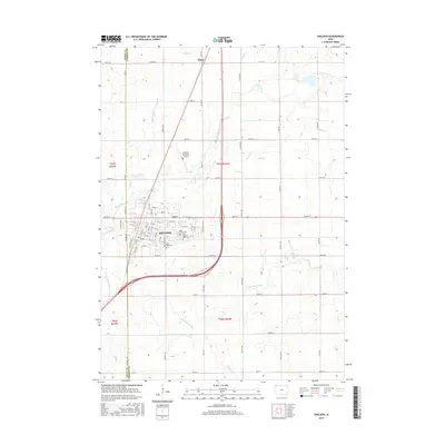
2015 Map of Sheldon
USGS Topo · Published 2015About this map
Sheldon sits at the western edge of O'Brien County, where the Northwest Iowa prairie is etched by the meandering courses of the Floyd River and the Little Floyd River. This 2015 survey details the city's modern footprint, including the Sheldon Municipal Airport and a dense grid of streets that transition into the straight section-line roads characteristic of the region's agricultural layout. Local genealogy and history are well-represented by the documented locations of East Lawn Cem, Saint Patricks Cem, and Saint Paul Cem, which serve as cornerstones for family researchers. To the north, the smaller settlement of Ritter marks a quiet point along the county line where Wolf Cr flows through the township. The surrounding landscape remains defined by its drainage network, with Engels Cr, Sweeney Cr, and Lamkin Cr carving subtle relief into the fertile plains.
Find a feature on this map
28 named features on this map. Tap any name to fly to it.
Don’t see what you’re looking for? This feature index may not catch every label — zoom into the map to look around manually.
Map Details
Editions of this 2015 Sheldon Map
This is the sole edition of this map. No revisions or reprints were ever made.
Other maps of this area

1954 · Fairmont
USGS Topo · 1:250,000

1958 · Fairmont
USGS Topo · 1:250,000

1964 · Hospers
USGS Topo · 1:24,000

1964 · Matlock
USGS Topo · 1:24,000

1964 · Sheldon SE
USGS Topo · 1:24,000

1964 · Sheldon
USGS Topo · 1:24,000

1964 · Primghar
USGS Topo · 1:24,000

1964 · Sanborn
USGS Topo · 1:24,000

1972 · Ashton
USGS Topo · 1:24,000
1972 · George East
USGS Topo · 1:24,000