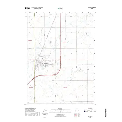
2018 Map of Sheldon
USGS Topo · Published 2018About this map
Sheldon serves as the primary hub in this corner of northwest Iowa, straddling the border between Sioux and O'Brien Counties. The landscape is defined by the organized grid of section lines and rural routes like 320th St and 360th St, typical of the region's agricultural layout. Waterways including the Floyd River and its tributary, the Little Floyd River, meander through the farmland, punctuated by smaller creeks such as Wolf Cr and Engels Cr. This survey details the town's growth toward the Sheldon Regional Airport and provides essential locations for genealogists, including East Lawn Cem, Saint Patricks Cem, and Saint Paul Cem. North of the main settlement, the small community of Ritter remains a distinct point on the map, connected by the highway corridor.
Find a feature on this map
53 named features on this map. Tap any name to fly to it.
Don’t see what you’re looking for? This feature index may not catch every label — zoom into the map to look around manually.
Map Details
Editions of this 2018 Sheldon Map
This is the sole edition of this map. No revisions or reprints were ever made.
Other maps of this area

1954 · Fairmont
USGS Topo · 1:250,000

1958 · Fairmont
USGS Topo · 1:250,000

1964 · Hospers
USGS Topo · 1:24,000

1964 · Matlock
USGS Topo · 1:24,000

1964 · Sheldon SE
USGS Topo · 1:24,000

1964 · Sheldon
USGS Topo · 1:24,000

1964 · Primghar
USGS Topo · 1:24,000

1964 · Sanborn
USGS Topo · 1:24,000

1972 · Ashton
USGS Topo · 1:24,000
1972 · George East
USGS Topo · 1:24,000