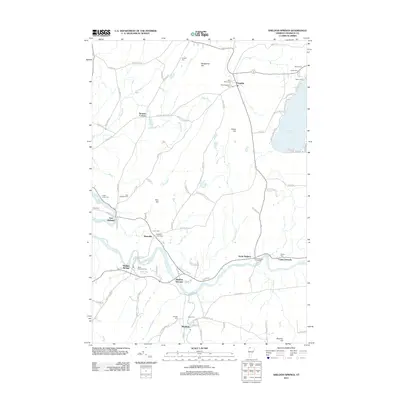
2012 Map of Sheldon Springs
USGS Topo · Published 2012About this map
The Missisquoi River and its tributary McGowan Brook define the valley landscape of central Franklin County, Vermont, where the small hamlets of Sheldon Springs and Sheldon Junction emerged as local hubs. The region's settlement pattern is closely tied to the water, with the Rock River carving through the northern hills near Bridgeman Hill and Gates Hill. Local heritage is preserved in numerous family and community burial grounds, including Willard Cem, Saint Anthonys Cem, and the unique North Sheldon Fish Cem. To the east, the shoreline of Lake Carmi and the nearby Camp Grounds suggest a landscape balanced between agricultural life and early 21st-century recreation. The presence of a Railroad Bed near the river indicates the corridor's history as a transportation artery, even as modern routes like Franklin Rd and Patterson Rd now serve the rural crossroads at Browns Corners and Shawville.
Find a feature on this map
93 named features on this map. Tap any name to fly to it.
Don’t see what you’re looking for? This feature index may not catch every label — zoom into the map to look around manually.
Map Details
Editions of this 2012 Sheldon Springs Map
This is the sole edition of this map. No revisions or reprints were ever made.
Other maps of this area

1914 · St. Albans
USGS Topo · 1:48,000

1916 · St. Albans
USGS Topo · 1:62,500

1920 · Franklin Pond
USGS Topo · 1:62,500

1922 · Enosburg Falls
USGS Topo · 1:48,000

1924 · Enosburg Falls
USGS Topo · 1:62,500

1943 · St. Albans
USGS Topo · 1:62,500

1944 · Enosburg Falls
USGS Topo · 1:62,500

1950 · Lake Champlain
USGS Topo · 1:250,000
1953 · Enosburg Falls
USGS Topo · 1:62,500

1958 · Lake Champlain
USGS Topo · 1:250,000