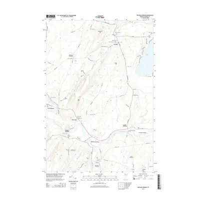
2015 Map of Sheldon Springs
USGS Topo · Published 2015About this map
The Missisquoi River carves a central path through this Franklin County landscape, defining the layout of historic settlements like Sheldon Springs and Sheldon Junction. This 2015 survey reveals a terrain characterized by agricultural valley floors and the rising slopes of the Green Mountains and Bridgeman Hill. The region's genealogy is preserved in numerous burial grounds, from the Sheldon Union Cem to the Saint Anthonys Cem, reflecting the area's long-established religious and community foundations. In the northeast, the shoreline of Lake Carmi serves as a major focal point, surrounded by access routes like Patton Shore Rd and Mullen Shore Rd. The map also traces the drainage patterns of Rock River and McGowan Brook, which feed into the Missisquoi, supporting the traditional river-valley settlement patterns seen at North Sheldon and Shawville.
Find a feature on this map
89 named features on this map. Tap any name to fly to it.
Don’t see what you’re looking for? This feature index may not catch every label — zoom into the map to look around manually.
Map Details
Editions of this 2015 Sheldon Springs Map
This is the sole edition of this map. No revisions or reprints were ever made.
Other maps of this area

1914 · St. Albans
USGS Topo · 1:48,000

1916 · St. Albans
USGS Topo · 1:62,500

1920 · Franklin Pond
USGS Topo · 1:62,500

1922 · Enosburg Falls
USGS Topo · 1:48,000

1924 · Enosburg Falls
USGS Topo · 1:62,500

1943 · St. Albans
USGS Topo · 1:62,500

1944 · Enosburg Falls
USGS Topo · 1:62,500

1950 · Lake Champlain
USGS Topo · 1:250,000
1953 · Enosburg Falls
USGS Topo · 1:62,500

1958 · Lake Champlain
USGS Topo · 1:250,000