
1936 Map of Shellmound
USGS Topo · Published 1936About this map
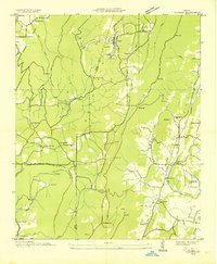
Sand Mountain dominates the topography of this three-state border region, where the Tennessee-Georgia and Alabama-Georgia lines meet. The 1936 survey documents the landscape just before significant transformation by the Tennessee Valley Authority, specifically showing the boundary of the Proposed Guntersville Res. Along the river bend, the community of Shellmound sits near the Shellmound Station and the historic Nickajack Cave, a landmark of early regional travel.
Find a feature on this map
63 named features on this map. Tap any name to fly to it.
Don’t see what you’re looking for? This feature index may not catch every label — zoom into the map to look around manually.
Map Details
Editions of this 1936 Shellmound Map
This is the sole edition of this map. No revisions or reprints were ever made.
Other maps of this area

1886 · Ringgold
USGS Topo · 1:125,000

1886 · Stevenson
USGS Topo · 1:125,000

1888 · Chattanooga
USGS Topo · 1:125,000

1892 · Ringgold
USGS Topo · 1:125,000

1892 · Stevenson
USGS Topo · 1:125,000

1893 · Chattanooga
USGS Topo · 1:125,000

1895 · Stevenson
USGS Topo · 1:125,000

1895 · Sewanee
USGS Topo · 1:125,000
1935 · Durham
USGS Topo · 1:24,000

1936 · Trenton
USGS Topo · 1:24,000