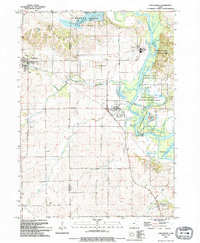
1993 Map of Shellsburg
USGS Topo · Published 1994About this map
The Cedar River corridor dominates this 1993 study of eastern Benton and western Linn counties, revealing a landscape defined by expansive state-managed conservation areas and utility infrastructure. The Duane Arnold Energy Center stands prominently near Palo, surrounded by a network of recreational and natural lands including Pleasant Creek State Park and the sprawling Chain Lakes State Game Management Area. This era shows the transition of the river valley from traditional agriculture to a hybrid of power generation and protected wilderness.
Find a feature on this map
40 named features on this map. Tap any name to fly to it.
Don’t see what you’re looking for? This feature index may not catch every label — zoom into the map to look around manually.
Map Details
Editions of this 1993 Shellsburg Map
This is the sole edition of this map. No revisions or reprints were ever made.
Other maps of this area

1887 · Cedar Rapids
USGS Topo · 1:62,500

1888 · Shellsburg
USGS Topo · 1:62,500

1888 · Marion
USGS Topo · 1:62,500

1888 · Amana
USGS Topo · 1:62,500

1889 · Marion
USGS Topo · 1:62,500

1889 · Amana
USGS Topo · 1:62,500

1889 · Shellsburg
USGS Topo · 1:62,500

1891 · Cedar Rapids
USGS Topo · 1:62,500

1899 · Amana
USGS Topo · 1:62,500

1899 · Shellsburg
USGS Topo · 1:62,500