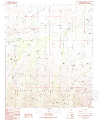
1985 Map of Shingle Mill Mountain
USGS Topo · Published 1986About this map
Pinaleno Mountains dominate the southern portion of this Graham County landscape, where the Coronado National Forest boundary marks the transition into the high terrain of Shingle Mill Mountain. The map reveals a complex network of drainage systems and water sources essential for livestock and local travel, including Matthews Wash, Cottonwood Creek, and the aptly named Bigler Ponds. Numerous specialized water features like Seven Cross Tank and Webb 1 Tank suggest a landscape managed for ranching. To the west, the topography levels out at Mexican Mesa before dropping into Dead Steer Canyon, while the northern reaches provide a stark contrast with the open, level ground of the Flat. Primitive transport is documented through various 4wd tracks and a traditional Pack Trail winding through Carter Canyon.
Find a feature on this map
47 named features on this map. Tap any name to fly to it.
Don’t see what you’re looking for? This feature index may not catch every label — zoom into the map to look around manually.
Map Details
Editions of this 1985 Shingle Mill Mountain Map
This is the sole edition of this map. No revisions or reprints were ever made.
Other maps of this area

1940 · Sierra Bonita Ranch
USGS Topo · 1:62,500

1942 · Sierra Bonita Ranch
USGS Topo · 1:62,500

1942 · Mt. Graham
USGS Topo · 1:62,500

1943 · Sierra Bonita Ranch
USGS Topo · 1:62,500

1944 · Jackson Mtn.
USGS Topo · 1:62,500

1945 · Mt. Graham
USGS Topo · 1:62,500

1946 · Jackson Mtn.
USGS Topo · 1:62,500

1954 · Silver City
USGS Topo · 1:250,000

1956 · Tucson
USGS Topo · 1:250,000

1958 · Silver City
USGS Topo · 1:250,000