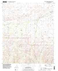
1997 Map of Shingle Mill Mountain
USGS Topo · Published 2002About this map
Coronado National Forest dominates the southern reaches of this Graham County landscape, where the northern slopes of the Pinaleno Mountains rise sharply from the desert floor. The terrain is defined by a dense network of water management features and cattle-related infrastructure, indicating a ranching economy reliant on scattered water sources. Numerous tanks such as Seven Cross Tank and Stockpond Tank are situated near drainage mouths like Wide Mouth Canyon, while larger alluvial features like Bear Springs Flat provide more level ground amidst the ridges. A variety of named springs, including Ringcone Spring and Greene Spring, emphasize the vital nature of water in this arid environment. Transportation through the higher elevations is limited to primitive routes like the Pack Trail, which winds through Shingle Mill Canyon and across Blair Canyon, connecting the deep interior of the forest to the washes below.
Find a feature on this map
41 named features on this map. Tap any name to fly to it.
Don’t see what you’re looking for? This feature index may not catch every label — zoom into the map to look around manually.
Map Details
Editions of this 1997 Shingle Mill Mountain Map
This is the sole edition of this map. No revisions or reprints were ever made.
Other maps of this area

1940 · Sierra Bonita Ranch
USGS Topo · 1:62,500

1942 · Sierra Bonita Ranch
USGS Topo · 1:62,500

1942 · Mt. Graham
USGS Topo · 1:62,500

1943 · Sierra Bonita Ranch
USGS Topo · 1:62,500

1944 · Jackson Mtn.
USGS Topo · 1:62,500

1945 · Mt. Graham
USGS Topo · 1:62,500

1946 · Jackson Mtn.
USGS Topo · 1:62,500

1954 · Silver City
USGS Topo · 1:250,000

1956 · Tucson
USGS Topo · 1:250,000

1958 · Silver City
USGS Topo · 1:250,000