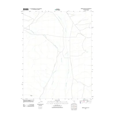
2012 Map of Shingle Pass SE
USGS Topo · Published 2012About this map
Big Spring Wash and Cave Valley Wash define the drainage patterns across this high desert landscape in Lincoln County. The mapping shows a network of remote corridors, including N Cave Valley Rd and S Cave Valley Rd, which provide access through the arid basin. Near the eastern edge, Quartzite Spring stands as a vital water source in an otherwise dry expanse. To the southwest, the terrain shifts significantly at the entrance to Sawmill Canyon. This 2012 survey illustrates the modern configuration of unpaved desert routes like Patterson Pass Rd, reflecting the sparse infrastructure and rugged character typical of the eastern Nevada interior.
Find a feature on this map
7 named features on this map. Tap any name to fly to it.
Don’t see what you’re looking for? This feature index may not catch every label — zoom into the map to look around manually.
Map Details
Editions of this 2012 Shingle Pass SE Map
This is the sole edition of this map. No revisions or reprints were ever made.
Other maps of this area

1956 · Lund
USGS Topo · 1:250,000

1960 · Lund
USGS Topo · 1:250,000

1969 · Shingle Pass
USGS Topo · 1:24,000

1969 · Parker Station
USGS Topo · 1:24,000

1969 · Shingle Pass SE
USGS Topo · 1:24,000

1969 · Haggerty Spring
USGS Topo · 1:24,000

1971 · Sidehill Spring
USGS Topo · 1:24,000

1971 · Cave Valley Well
USGS Topo · 1:24,000
1973 · Dutch John Mtn
USGS Topo · 1:24,000
1978 · Mt. Grafton
USGS Topo · 1:24,000