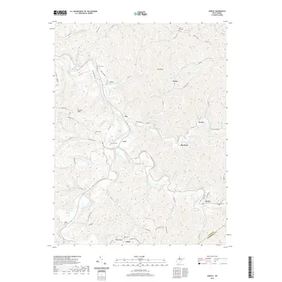
2019 Map of Shirley
USGS Topo · Published 2019About this map
Middle Island Creek winds through this West Virginia landscape, dictating the placement of valley settlements and narrow roads. The area is defined by its rural hamlets, including the communities of Shirley, Frew, and Tyler, where the terrain transitions into sharp elevations like Kingsley Ridge and Blue Ridge. Genealogy researchers will find several well-preserved family and community burial grounds, such as Spring Hill Cem, Underwood Cem, and Beechwood Cem. The map illustrates a complex drainage system with numerous named runs—including Conaway Run, Purgatory Run, and McElroy Creek—that feed into the larger creek system. Further south, the settlement of Wilbur sits at the base of Wilbur Ridge, illustrating the traditional Appalachian pattern of ridge-and-hollow habitation that persists in Tyler and Doddridge counties.
Find a feature on this map
76 named features on this map. Tap any name to fly to it.
Don’t see what you’re looking for? This feature index may not catch every label — zoom into the map to look around manually.
Map Details
Editions of this 2019 Shirley Map
This is the sole edition of this map. No revisions or reprints were ever made.
Other maps of this area

1903 · Littleton
USGS Topo · 1:62,500

1905 · Centerpoint
USGS Topo · 1:62,500

1905 · West Union
USGS Topo · 1:62,500

1905 · Littleton
USGS Topo · 1:62,500

1906 · New Martinsville
USGS Topo · 1:62,500

1924 · New Martinsville
USGS Topo · 1:62,500

1924 · Centerpoint
USGS Topo · 1:62,500

1924 · Littleton
USGS Topo · 1:62,500

1924 · West Union
USGS Topo · 1:62,500

1925 · Centerpoint
USGS Topo · 1:62,500