1976 Map of Shirley
USGS Topo · Published 1979About this map
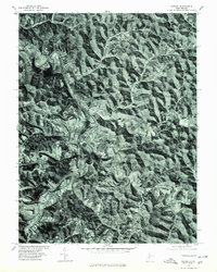
Centerville and Shirley stand as the primary settlements within this 1976 orthophotoquad, which captures the densely wooded and deeply dissected terrain of Tyler County. The serpentine path of Middle Island Creek dominates the landscape, its winding valley providing the only level ground for agriculture and transit in an otherwise heavily forested region. This imagery, produced in cooperation with the Soil Conservation Service, offers a detailed look at the land use patterns during the mid-1970s, showing how small homesteads and clearings were integrated into the sharp ridges and narrow hollows characteristic of the West Virginia panhandle. The aerial perspective reveals the relationship between the sinuous watercourse and the rural road network that follows the creek's natural corridor.
Find a feature on this map
3 named features on this map. Tap any name to fly to it.
Don’t see what you’re looking for? This feature index may not catch every label — zoom into the map to look around manually.
Map Details
Editions of this 1976 Shirley Map
This is the sole edition of this map. No revisions or reprints were ever made.
Other maps of this area

1903 · Littleton
USGS Topo · 1:62,500

1905 · Centerpoint
USGS Topo · 1:62,500

1905 · West Union
USGS Topo · 1:62,500

1905 · Littleton
USGS Topo · 1:62,500

1906 · New Martinsville
USGS Topo · 1:62,500

1924 · New Martinsville
USGS Topo · 1:62,500

1924 · Centerpoint
USGS Topo · 1:62,500
1924 · Littleton
USGS Topo · 1:62,500

1924 · West Union
USGS Topo · 1:62,500

1925 · Centerpoint
USGS Topo · 1:62,500