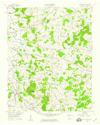
1958 Map of Shop Springs
USGS Topo · Published 1959About this map
Shop Springs and the surrounding Wilson County hillsides were shaped by a network of rural churches and schoolhouses during the late 1950s. The landscape is defined by the winding course of Spring Creek and its many tributaries, including Jennings Fork and the Big Caney Branch. Topographic landmarks like Jennings Knob and Hankins Hill rise above a patchwork of family farms connected by established routes such as Old Rome Road and Cainsville Road.
Find a feature on this map
47 named features on this map. Tap any name to fly to it.
Don’t see what you’re looking for? This feature index may not catch every label — zoom into the map to look around manually.
Map Details
Editions of this 1958 Shop Springs Map
2 editions found
Other maps of this area

1942 · Statesville
USGS Topo · 1:100,000

1942 · Gallatin
USGS Topo · 1:100,000

1942 · Lebanon
USGS Topo · 1:100,000

1951 · Lebanon
USGS Topo · 1:24,000

1955 · Hunters Point
USGS Topo · 1:24,000

1956 · Vine
USGS Topo · 1:24,000

1956 · Nashville
USGS Topo · 1:250,000

1958 · New Middleton
USGS Topo · 1:24,000

1958 · Bellwood
USGS Topo · 1:24,000

1958 · Watertown
USGS Topo · 1:24,000