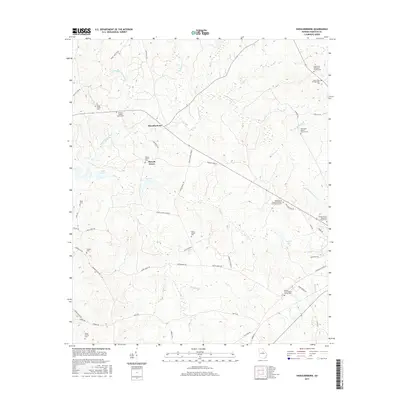
2017 Map of Shoulderbone
USGS Topo · Published 2017About this map
Shoulderbone and Howell Grove anchor this section of Hancock County, where the landscape is defined by the intricate drainage of Shoulderbone Creek and its many tributaries. The area is notable for its high density of ancestral burial grounds, including the Green Hudson Family Cem, Mosley Family Cem, and the Barnes Rives-Warren Family Cem near the southern edge. These family-named landmarks suggest a deep-rooted agricultural history that predates the modern expansion of Lake Sinclair to the west. The map also documents numerous rural congregations and their associated grounds, such as Mount Zion Methodist Church Cem and Hunts Chapel Cem, which served as the social and spiritual hubs for the scattered farmsteads. The network of local roads like Stem Bridge Rd and Hunts Chapel Rd follows the natural contours of the ridges between Fort Creek and Beaverdam Creek.
Find a feature on this map
62 named features on this map. Tap any name to fly to it.
Don’t see what you’re looking for? This feature index may not catch every label — zoom into the map to look around manually.
Map Details
Editions of this 2017 Shoulderbone Map
This is the sole edition of this map. No revisions or reprints were ever made.
Other maps of this area

1912 · Milledgeville
USGS Topo · 1:62,500

1953 · Athens
USGS Topo · 1:250,000

1958 · Athens
USGS Topo · 1:250,000

1959 · Athens
USGS Topo · 1:250,000

1961 · Warthen NW
USGS Topo · 1:24,000

1963 · Athens
USGS Topo · 1:250,000

1972 · Liberty
USGS Topo · 1:24,000

1972 · Shoulderbone
USGS Topo · 1:24,000

1972 · Sparta NW
USGS Topo · 1:24,000
1972 · Devereux
USGS Topo · 1:24,000