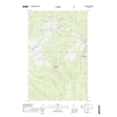
2020 Map of Shuksan Arm
USGS Topo · Published 2020About this map
Heather Meadows serves as a central hub for this high-altitude landscape, where the Pacific NW National Scenic Trail traverses the ridges and valleys of the Mount Baker National Forest. The topography is defined by its glacial activity, with the Table Mountain Glacier, White Salmon Glacier, and Sulphide Glacier clinging to the steep terrain near the boundary of North Cascades National Park. This 2020 survey records a complex hydrologic network of alpine basins, including Bagley Lakes, Arbuthnet Lake, and the remote Maiden Lake. Significant recreational and geological landmarks are noted throughout, from the thermal waters of Baker Hot Spring to the sharp ascent of Fisher Chimney and the prominent volcanic shelf of Table Mountain. The map also details seasonal routes like the Martin Lake X-Country Ski 1130 (Snow) trail, reflecting the modern management of this wilderness area.
Find a feature on this map
74 named features on this map. Tap any name to fly to it.
Don’t see what you’re looking for? This feature index may not catch every label — zoom into the map to look around manually.
Map Details
Editions of this 2020 Shuksan Arm Map
This is the sole edition of this map. No revisions or reprints were ever made.
Other maps of this area

1909 · Mt Baker
USGS Topo · 1:192,000

1915 · Mt. Baker
USGS Topo · 1:250,000

1952 · Lake Shannon
USGS Topo · 1:62,500

1952 · Mt. Baker
USGS Topo · 1:62,500

1952 · Hamilton
USGS Topo · 1:62,500

1953 · Mt Shuksan
USGS Topo · 1:62,500

1955 · Concrete
USGS Topo · 1:250,000

1958 · Concrete
USGS Topo · 1:250,000

1962 · Concrete
USGS Topo · 1:250,000
1973 · Hamilton
USGS Topo · 1:62,500