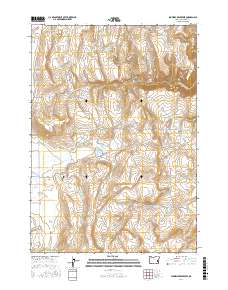
2017 Map of Shumway Reservoir
USGS Topo · Published 2017About this map
Creston anchors the southwestern edge of this High Desert landscape in Malheur County, where a complex network of ranching infrastructure defines the terrain. The map reveals an intricate system of water management essential for livestock in this arid region, featuring numerous named catchments such as Shumway Reservoir, Arrien Reservoir, and Easterday Reservoir. These water sources are linked by a rugged road network, including Shumway Rd and Shumway Ranch Rd, which follow the natural drainages of Cottonwood Creek and Granite Creek. Named springs like Wire Corral Springs and McConnell Springs offer vital points of interest for local history and genealogy researchers tracking land use and grazing patterns. The survey provides a clear view of the topographical challenges of the area, from the elevations of Lake Ridge down to the creek beds of Big Granite Creek and Little Granite Creek.
Find a feature on this map
41 named features on this map. Tap any name to fly to it.
Don’t see what you’re looking for? This feature index may not catch every label — zoom into the map to look around manually.
Map Details
Editions of this 2017 Shumway Reservoir Map
This is the sole edition of this map. No revisions or reprints were ever made.
Other maps of this area

1955 · Burns
USGS Topo · 1:250,000

1955 · Boise
USGS Topo · 1:250,000

1958 · Burns
USGS Topo · 1:250,000

1958 · Boise
USGS Topo · 1:250,000

1959 · Burns
USGS Topo · 1:250,000

1962 · Boise
USGS Topo · 1:250,000

1972 · Tims Peak
USGS Topo · 1:24,000

1972 · Shumway Reservoir
USGS Topo · 1:24,000

1972 · Alder Creek
USGS Topo · 1:24,000
1972 · Skull Springs
USGS Topo · 1:24,000