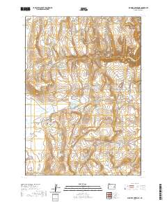
2020 Map of Shumway Reservoir
USGS Topo · Published 2020About this map
Creston sits at the southwestern edge of this high-desert landscape in Malheur County, where a complex network of water management features reveals the region's ranching heritage. The terrain is defined by a dense concentration of man-made water sources, including the centrally located Shumway Reservoir and numerous smaller catchments like Caterpillar Butte Reservoir and Brass Cap Reservoir. These reservoirs, often fed by intermittent drainages such as Granite Creek and Little Granite Creek, represent the essential infrastructure required for livestock survival in this arid corner of Oregon.
Find a feature on this map
40 named features on this map. Tap any name to fly to it.
Don’t see what you’re looking for? This feature index may not catch every label — zoom into the map to look around manually.
Map Details
Editions of this 2020 Shumway Reservoir Map
This is the sole edition of this map. No revisions or reprints were ever made.
Other maps of this area

1955 · Burns
USGS Topo · 1:250,000

1955 · Boise
USGS Topo · 1:250,000

1958 · Burns
USGS Topo · 1:250,000

1958 · Boise
USGS Topo · 1:250,000

1959 · Burns
USGS Topo · 1:250,000

1962 · Boise
USGS Topo · 1:250,000

1972 · Tims Peak
USGS Topo · 1:24,000

1972 · Shumway Reservoir
USGS Topo · 1:24,000

1972 · Alder Creek
USGS Topo · 1:24,000
1972 · Skull Springs
USGS Topo · 1:24,000