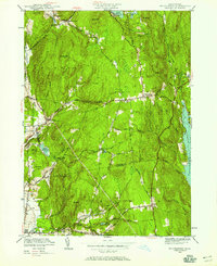
1950 Map of Shutesbury
USGS Topo · Published 1958About this map
The western shoreline of the Quabbin Reservoir dominates the eastern edge of this landscape, reflecting a massive transformation of the Swift River Valley. To the west, the upland terrain is dotted with small hamlets and agricultural clearings such as Cooleyville, Dudleyville, and Moores Corner. The central village of Shutesbury serves as a focal point, situated near the headwaters of numerous brooks that drain the surrounding ridges, including Doolittle Brook and Osgood Brook. In the southern portion of the sheet, the town of Pelham and the settlement at West Pelham are visible, connected by a network of rural roads like Pelham Hill Road. Educational and civic life are marked by the Rhodes Sch and local burial grounds including the West Cem and Valley Cem. Numerous smaller bodies of water, such as Lake Wyola and Atkins Reservoir, illustrate the region's reliance on managed water resources for local communities and industry during the mid-century era.
Find a feature on this map
68 named features on this map. Tap any name to fly to it.
Don’t see what you’re looking for? This feature index may not catch every label — zoom into the map to look around manually.
Map Details
Editions of this 1950 Shutesbury Map
2 editions found
Other maps of this area

1885 · Northampton
USGS Topo · 1:62,500

1886 · Northampton
USGS Topo · 1:62,500

1887 · Warwick
USGS Topo · 1:62,500

1887 · Belchertown
USGS Topo · 1:62,500

1889 · Warwick
USGS Topo · 1:62,500

1890 · Belchertown
USGS Topo · 1:62,500

1890 · Greenfield
USGS Topo · 1:62,500

1891 · Northampton
USGS Topo · 1:62,500

1893 · Northampton
USGS Topo · 1:62,500

1893 · Belchertown
USGS Topo · 1:62,500