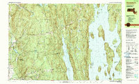
1990 Map of Shutesbury
USGS Topo · Published 1990About this map
The Quabbin Reservoir dominates the eastern half of this 1990 survey, its waters surrounding former hilltops now known as Mount Zion, Carrick Island, and Stevens Island. This landscape reflects the massive mid-century transformation of the Swift River Valley, which submerged several towns to create the reservoir. On the remaining dry ground, the map reveals a network of upland villages and wooded ridges, including Shutesbury, Cooleyville, and North Prescott. Much of the terrain is preserved within the Shutesbury State Forest and the Federated Womens Club State Forest, while the western edge transitions toward the higher elevations of Brushy Mountain and Mt Orient. The presence of numerous cemeteries and churches near small settlements like Locks Village provides essential touchpoints for genealogists tracing families in these rural hill towns before modern development.
Find a feature on this map
60 named features on this map. Tap any name to fly to it.
Don’t see what you’re looking for? This feature index may not catch every label — zoom into the map to look around manually.
Map Details
Editions of this 1990 Shutesbury Map
2 editions found
Other maps of this area

1885 · Northampton
USGS Topo · 1:62,500

1886 · Northampton
USGS Topo · 1:62,500

1887 · Warwick
USGS Topo · 1:62,500

1887 · Belchertown
USGS Topo · 1:62,500

1887 · Winchendon
USGS Topo · 1:62,500

1887 · Barre
USGS Topo · 1:62,500

1889 · Barre
USGS Topo · 1:62,500

1889 · Warwick
USGS Topo · 1:62,500

1890 · Belchertown
USGS Topo · 1:62,500

1890 · Greenfield
USGS Topo · 1:62,500