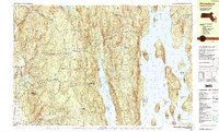
1990 Map of Shutesbury
USGS Topo · Published 1990About this map
Quabbin Reservoir dominates the eastern half of this landscape, its expansive waters surrounding numerous islands like Mount L and Mount Zion. The geography here reflects the dramatic mid-20th-century transformation of the Swift River Valley, where former town centers such as Prescott Center and North Prescott were partially submerged or isolated by the reservoir's creation. On the mainland to the west, the village of Shutesbury serves as a hub, connected by a network of rural routes including Pelham Rd and Wendell Road.
Find a feature on this map
117 named features on this map. Tap any name to fly to it.
Don’t see what you’re looking for? This feature index may not catch every label — zoom into the map to look around manually.
Map Details
Editions of this 1990 Shutesbury Map
2 editions found
Other maps of this area

1885 · Northampton
USGS Topo · 1:62,500

1886 · Northampton
USGS Topo · 1:62,500

1887 · Warwick
USGS Topo · 1:62,500

1887 · Belchertown
USGS Topo · 1:62,500

1887 · Winchendon
USGS Topo · 1:62,500

1887 · Barre
USGS Topo · 1:62,500

1889 · Barre
USGS Topo · 1:62,500

1889 · Warwick
USGS Topo · 1:62,500

1890 · Belchertown
USGS Topo · 1:62,500

1890 · Greenfield
USGS Topo · 1:62,500