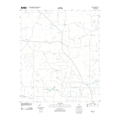
2011 Map of Sibbie
USGS Topo · Published 2011About this map
Sibbie and Abba anchor this rural Georgia landscape, characterized by a complex network of agricultural roads and family-named landmarks. The terrain is defined by its subtle water systems, including the South Prong House Creek and Willacoochee Creek, as well as distinctive geological features like the Blue Sink and Sink of the Creek. A clear pattern of local heritage is visible through the numerous burial grounds distributed across the quadrangle, such as Reid Cemetery, Mims Cemetery, and Luke Cemetery, which often sit near intersections or original farmsteads.
Find a feature on this map
72 named features on this map. Tap any name to fly to it.
Don’t see what you’re looking for? This feature index may not catch every label — zoom into the map to look around manually.
Map Details
Editions of this 2011 Sibbie Map
This is the sole edition of this map. No revisions or reprints were ever made.
Other maps of this area

1953 · Waycross
USGS Topo · 1:250,000

1958 · Waycross
USGS Topo · 1:250,000

1972 · Fitzgerald East
USGS Topo · 1:24,000

1972 · Queensland
USGS Topo · 1:24,000

1973 · Irwinville
USGS Topo · 1:24,000

1973 · Fitzgerald West
USGS Topo · 1:24,000

1974 · Rebecca
USGS Topo · 1:24,000
1974 · Abbeville South
USGS Topo · 1:24,000
1977 · Queensland
USGS Topo · 1:24,000
1977 · Rochelle
USGS Topo · 1:24,000