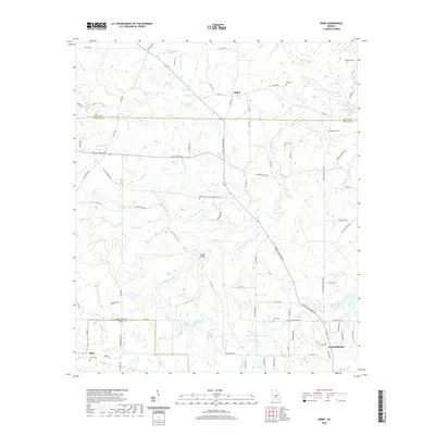
2020 Map of Sibbie
USGS Topo · Published 2020About this map
Sibbie and Abba sit within a landscape of South Georgia wetlands and family-named cemeteries at the intersection of Irwin, Ben Hill, and Wilcox counties. This area is defined by its intricate hydrography, featuring unique karst-like landforms such as Blue Sink, Black Lake, and the evocative Devils Den. The rural road network, including Salem Church Rd and Dewey McGlamry Rd, connects numerous local burial grounds like Bethlehem Cem and Mims Cem, reflecting a long-standing pattern of family settlement. To the southeast, the northern reaches of Fitzgerald begin to appear, while smaller crossroads like Double Bridges mark the transitions between drainage basins for House Cr and the S Prong House Cr. The map captures the quiet, agricultural character of the Wiregrass Region, where the land is carved by numerous small streams such as Stone Cr and Player Cr.
Find a feature on this map
97 named features on this map. Tap any name to fly to it.
Don’t see what you’re looking for? This feature index may not catch every label — zoom into the map to look around manually.
Map Details
Editions of this 2020 Sibbie Map
This is the sole edition of this map. No revisions or reprints were ever made.
Other maps of this area

1953 · Waycross
USGS Topo · 1:250,000

1958 · Waycross
USGS Topo · 1:250,000

1972 · Fitzgerald East
USGS Topo · 1:24,000

1972 · Queensland
USGS Topo · 1:24,000

1973 · Irwinville
USGS Topo · 1:24,000

1973 · Fitzgerald West
USGS Topo · 1:24,000

1974 · Rebecca
USGS Topo · 1:24,000
1974 · Abbeville South
USGS Topo · 1:24,000
1977 · Queensland
USGS Topo · 1:24,000
1977 · Rochelle
USGS Topo · 1:24,000