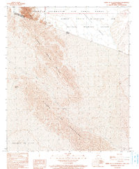
1990 Map of Sierra De La Lechuguilla
USGS Topo · Published 1991About this map
Sierra Tinajas Altas and Sierra Los Alacranes dominate this arid landscape along the international border between the United States and Mexico. This 1990 provisional survey documents a stark transition where the Lechuguilla Desert meets the Desierto de Altar in Sonora. Most of the territory is defined by large federal tracts, including the Barry M Goldwater Air Force Range and the Cabeza Prieta Wilderness and National Wildlife Refuge, reflecting the region's late-century management as both a military proving ground and a protected desert habitat. Evidence of human activity is sparse, marked primarily by the Joya Vieja (Pleta Cobre) site and the intermittent La Jolla Wash, which provides a topographical record of seasonal drainage patterns in this corner of Yuma County.
Find a feature on this map
12 named features on this map. Tap any name to fly to it.
Don’t see what you’re looking for? This feature index may not catch every label — zoom into the map to look around manually.
Map Details
Editions of this 1990 Sierra De La Lechuguilla Map
This is the sole edition of this map. No revisions or reprints were ever made.
Other maps of this area

1942 · Yuma
USGS Topo · 1:250,000

1953 · Ajo
USGS Topo · 1:250,000

1954 · El Centro
USGS Topo · 1:250,000

1955 · El Centro
USGS Topo · 1:250,000

1957 · Ajo
USGS Topo · 1:250,000

1958 · Ajo
USGS Topo · 1:250,000

1958 · El Centro
USGS Topo · 1:250,000

1961 · El Centro
USGS Topo · 1:250,000

1962 · Ajo
USGS Topo · 1:250,000

1963 · Ajo
USGS Topo · 1:250,000