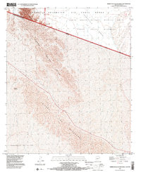
1996 Map of Sierra De La Lechuguilla
USGS Topo · Published 2000About this map
The Arizona Sonora border defines this desert landscape, where the international boundary cuts a sharp diagonal through the arid terrain of the Cabeza Prieta Desert. The topographic detail highlights the dramatic rise of the Sierra Tinajas Altas and the Sierra de la Lechuguilla, showcasing the steep elevation changes that characterize the borderlands. To the north, the Barry M Goldwater Air Force Range and the Cabeza Prieta National Wildlife Refuge indicate a region dedicated to both military use and environmental conservation. South of the border, the terrain transitions into the Desierto de Altar and the Sierra de los Alacranes. This map illustrates the intersection of national boundaries and protected wilderness areas, providing a clear view of the Cabeza Prieta Wilderness and its relationship to the surrounding desert reaches.
Find a feature on this map
12 named features on this map. Tap any name to fly to it.
Don’t see what you’re looking for? This feature index may not catch every label — zoom into the map to look around manually.
Map Details
Editions of this 1996 Sierra De La Lechuguilla Map
This is the sole edition of this map. No revisions or reprints were ever made.
Other maps of this area

1942 · Yuma
USGS Topo · 1:250,000

1953 · Ajo
USGS Topo · 1:250,000

1954 · El Centro
USGS Topo · 1:250,000

1955 · El Centro
USGS Topo · 1:250,000

1957 · Ajo
USGS Topo · 1:250,000

1958 · Ajo
USGS Topo · 1:250,000

1958 · El Centro
USGS Topo · 1:250,000

1961 · El Centro
USGS Topo · 1:250,000

1962 · Ajo
USGS Topo · 1:250,000

1963 · Ajo
USGS Topo · 1:250,000