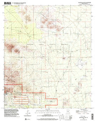
1996 Map of Silver Bell East
USGS Topo · Published 2003About this map
Mining operations and the desert landscapes of Pima County define this survey, which captures a region in transition as industrial sites sit alongside the Ironwood Forest National Monument. To the southwest, the Silver Bell (Site) is surrounded by evidence of intensive excavation, including a large Tailings Pond, numerous Mine Shafts, and an Adit near Portland Ridge. This proximity of heavy industry to protected lands creates a stark contrast between the modified terrain of the copper mines and the undisturbed peaks of the Silver Bell Mountains.
Find a feature on this map
22 named features on this map. Tap any name to fly to it.
Don’t see what you’re looking for? This feature index may not catch every label — zoom into the map to look around manually.
Map Details
Editions of this 1996 Silver Bell East Map
This is the sole edition of this map. No revisions or reprints were ever made.
Other maps of this area

1934 · Tucson Mountains
USGS Topo · 1:125,000

1934 · Silver Bell
USGS Topo · 1:125,000

1934 · Newman Peak
USGS Topo · 1:125,000

1947 · Red Rock
USGS Topo · 1:62,500

1947 · Eloy
USGS Topo · 1:62,500

1948 · Eloy
USGS Topo · 1:62,500

1956 · Tucson
USGS Topo · 1:250,000

1958 · Tucson
USGS Topo · 1:250,000

1959 · Tucson
USGS Topo · 1:250,000

1959 · Vaca Hills
USGS Topo · 1:62,500