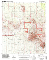
1996 Map of Silver Bell West
USGS Topo · Published 2003About this map
The Silver Bell Mine dominates this Pima County landscape, its extensive open-pit operations and associated Mine Shafts carved into the eastern slopes of the West Silver Bell Mountains. This 1996 data reveals a transition zone where heavy industrial extraction meets the protected lands of the Ironwood Forest National Monument. To the south, the terrain descends toward the Tohono O'odham Indian Reservation, marked by the seasonal drainage of Mammoth Wash and Tiro Wash. Historically significant landmarks include the Silverbell (Site) and the Silver Bell Cemetery, preserving the footprint of earlier mining generations. Rugged volcanic and sedimentary formations like Quartzite Peak, Jesuit Hill, and Malpais Hill define the topographic character, while isolated Prospects scattered across the range suggest the broader search for mineral wealth that shaped this desert region.
Find a feature on this map
23 named features on this map. Tap any name to fly to it.
Don’t see what you’re looking for? This feature index may not catch every label — zoom into the map to look around manually.
Map Details
Editions of this 1996 Silver Bell West Map
This is the sole edition of this map. No revisions or reprints were ever made.
Other maps of this area

1934 · Tucson Mountains
USGS Topo · 1:125,000

1934 · Silver Bell
USGS Topo · 1:125,000

1934 · Newman Peak
USGS Topo · 1:125,000

1947 · Red Rock
USGS Topo · 1:62,500

1947 · Eloy
USGS Topo · 1:62,500

1948 · Eloy
USGS Topo · 1:62,500

1956 · Tucson
USGS Topo · 1:250,000

1958 · Tucson
USGS Topo · 1:250,000

1959 · Tucson
USGS Topo · 1:250,000

1959 · Vaca Hills
USGS Topo · 1:62,500