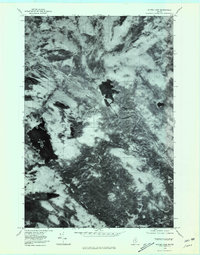
1978 Map of Silver Lake
USGS Topo · Published 1981About this map
Silver Lake sits at the center of this 1978 orthophotoquad, serving as a primary hydrologic feature in a heavily forested landscape of Piscataquis County. The imagery, captured via high-altitude aerial photography, reveals the raw topography of the Maine woods before the era of modern digital mapping. To the west, the dark expanse of Houston Pond is flanked by the significant elevations of Houston Mountain and Roundtop Mountain. The drainage pattern is dominated by the West Branch Pleasant River, which meanders across the northern half of the sheet. Unlike a traditional topographic map, this photographic record shows the density of timber and the specific paths of remote logging roads as they existed in the late 1970s. Waterways like Houston Brook and Roaring Brook cut through the timberland, illustrating the complex network of brooks that define this undeveloped region.
Find a feature on this map
7 named features on this map. Tap any name to fly to it.
Don’t see what you’re looking for? This feature index may not catch every label — zoom into the map to look around manually.
Map Details
Editions of this 1978 Silver Lake Map
This is the sole edition of this map. No revisions or reprints were ever made.
Other maps of this area

1940 · Sebec
USGS Topo · 1:48,000

1943 · Sebec
USGS Topo · 1:62,500

1950 · Sebec Lake
USGS Topo · 1:62,500

1952 · Jo-Mary Mountain
USGS Topo · 1:62,500

1952 · First Roach Pond
USGS Topo · 1:62,500

1954 · Millinocket
USGS Topo · 1:250,000

1958 · Millinocket
USGS Topo · 1:250,000

1960 · Millinocket
USGS Topo · 1:250,000
1978 · Hay Mountain
USGS Topo · 1:24,000
1978 · Barren Mountain East
USGS Topo · 1:24,000
Featured Places
- Bowerbank, ME
- Katahdin Iron Works Township, ME
- Williamsburg Township, ME
- T7 R9 NWP, ME
- Barnard Township, ME