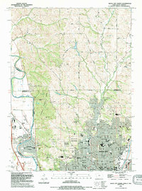
1994 Map of Sioux City North
USGS Topo · Published 1995About this map
Stone State Park and the rugged bluffs above the Big Sioux River define the transition between the Missouri River valley and the Iowa uplands in this mid-1990s survey. The map details the complex border region where Iowa, South Dakota, and the Plymouth Co and Woodbury Co lines converge. While the southern portion is dominated by the dense urban grid of Sioux City, featuring landmarks like Bishop Heelan High Sch and Logan Park Cemetery, the northern reach shows a landscape of section-line roads such as 305th St and the winding course of West Branch Perry Creek. The presence of the Sioux City State Prairie Preserve and Mt Lucia suggests a landscape where conservation and recreation zones meet the expanding industrial and residential reaches of North Sioux City and the Chicago and North Western rail corridor.
Find a feature on this map
75 named features on this map. Tap any name to fly to it.
Don’t see what you’re looking for? This feature index may not catch every label — zoom into the map to look around manually.
Map Details
Editions of this 1994 Sioux City North Map
This is the sole edition of this map. No revisions or reprints were ever made.
Other maps of this area

1898 · Elk Point
USGS Topo · 1:125,000

1901 · Elk Point
USGS Topo · 1:125,000

1907 · Elk Point
USGS Topo · 1:125,000

1955 · Sioux City
USGS Topo · 1:250,000

1958 · Sioux City
USGS Topo · 1:250,000

1959 · Sioux City
USGS Topo · 1:250,000

1963 · Sioux City South
USGS Topo · 1:24,000

1963 · Sioux City North
USGS Topo · 1:24,000

1963 · Elk Point NE
USGS Topo · 1:24,000

1963 · Jefferson
USGS Topo · 1:24,000