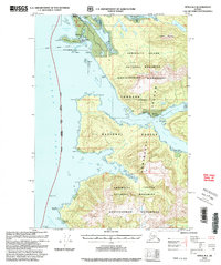
2000 Map of Sitka B-2
USGS Topo · Published 2003About this map
Admiralty Island's intricate coastline is the focal point of this survey, highlighting the Tlingit settlement at Angoon and the nearby legacy of Killisnoo. This area, protected within the Admiralty Island National Monument Kootznoowoo Wilderness, reveals a history of maritime commerce and resource extraction. Evidence of earlier industry persists in labels for a Coal Mine and the Lighthouse Reserve Killisnoo (Aban'd), while abandoned sites like Hood Bay (Aban'd) and Neltushkin (Aband) mark former centers of activity along the complex waterways.
Find a feature on this map
47 named features on this map. Tap any name to fly to it.
Don’t see what you’re looking for? This feature index may not catch every label — zoom into the map to look around manually.
Map Details
Editions of this 2000 Sitka B-2 Map
This is the sole edition of this map. No revisions or reprints were ever made.
Other maps of this area

1948 · Sitka B-3
USGS Topo · 1:63,360

1948 · Sitka B-1
USGS Topo · 1:63,360

1948 · Sitka A-3
USGS Topo · 1:63,360

1948 · Sitka C-2
USGS Topo · 1:63,360

1948 · Sitka A-2
USGS Topo · 1:63,360

1948 · Sitka C-3
USGS Topo · 1:63,360

1948 · Sitka C-1
USGS Topo · 1:63,360

1948 · Sitka B-2
USGS Topo · 1:63,360

1948 · Sitka A-1
USGS Topo · 1:63,360

1951 · Sitka
USGS Topo · 1:250,000