
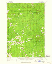
1932 Map of Skandia SE
USGS Topo · Published 1932About this map
The U S Upper Peninsula Experimental Forest spans the northwestern corner of this territory, marking an era of federal forest management along the boundary of Marquette and Alger Counties. Settlement is concentrated around the corridors of the Lake Superior and Ishpeming railroad and major thoroughfares like State Highway No 28. This 1932 field examination captures the rural infrastructure of the central Upper Peninsula, where the Dorsey Sch served local families near the junction of the Laughing Whitefish River and its various branches. Smaller outposts like Sundell, Dorsey, and Kiva are clearly delineated, showing a landscape defined by timber, small-scale transport, and the winding course of the West Br Whitefish River.
Find a feature on this map
21 named features on this map. Tap any name to fly to it.
Don’t see what you’re looking for? This feature index may not catch every label — zoom into the map to look around manually.
Map Details
Editions of this 1932 Skandia SE Map
This is the sole edition of this map. No revisions or reprints were ever made.
Other maps of this area

1932 · Skandia SW
USGS Topo · 1:31,680

1932 · Rock NE
USGS Topo · 1:31,680

1932 · Skandia NE
USGS Topo · 1:31,680

1932 · Rock NW
USGS Topo · 1:31,680

1950 · Skandia NW
USGS Topo · 1:31,680

1958 · Trenary
USGS Topo · 1:62,500

1958 · Au Train
USGS Topo · 1:62,500

1958 · Skandia
USGS Topo · 1:62,500
1958 · Rock
USGS Topo · 1:62,500

1958 · Marquette
USGS Topo · 1:250,000