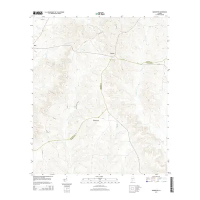
2014 Map of Skinnerton
USGS Topo · Published 2014About this map
Skinnerton sits at the intersection of a complex network of local roads that bridge the boundary between Monroe and Conecuh Counties. This area is defined by the winding drainages of the W Sepulga River and Murder Cr, which carve through the landscape along with Robinson Cr and Spring Cr. The settlement pattern is largely rural and dispersed, anchored by small communities like Midway and Riley. Genealogists may find particular value in the locations of the Midway Cem near the center of the quadrangle and Lone Star Cem to the southwest. The presence of named local routes such as Sanders Hill Rd, Fig Tree Rd, and Pipkins Cutoff suggests a deeply rooted local geography where family names and landmarks dictate the travel patterns across these creek-fed bottomlands.
Find a feature on this map
31 named features on this map. Tap any name to fly to it.
Don’t see what you’re looking for? This feature index may not catch every label — zoom into the map to look around manually.
Map Details
Editions of this 2014 Skinnerton Map
This is the sole edition of this map. No revisions or reprints were ever made.
Other maps of this area

1953 · Andalusia
USGS Topo · 1:250,000

1957 · Andalusia
USGS Topo · 1:250,000

1967 · Beatrice
USGS Topo · 1:24,000

1971 · Lyeffion
USGS Topo · 1:24,000

1971 · Skinnerton
USGS Topo · 1:24,000

1971 · China
USGS Topo · 1:24,000

1971 · Burnt Corn
USGS Topo · 1:24,000

1971 · Bethel
USGS Topo · 1:24,000

1971 · Beatrice
USGS Topo · 1:24,000
1981 · Nadawah
USGS Topo · 1:24,000