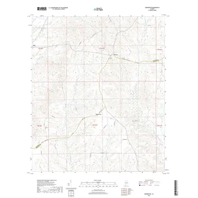
2018 Map of Skinnerton
USGS Topo · Published 2018About this map
The borderlands of Monroe and Conecuh counties reveal a landscape defined by an intricate network of waterways and rural crossroads. The settlement of Skinnerton sits centrally along Conecuh Co 1, while Midway occupies a high point to the north near Midway Cem. This topography is shaped by the drainage of the W Sepulga River and Murder Cr, which carve through the region's dense creek systems. A complex web of county roads and named routes like Fig Tree Rd and Sanders Hill Rd connect these small communities, indicating a pattern of local travel that follows the contours of the land. Genealogists may find value in locating the Lone Star Cem tucked in the western portion of the map, and the numerous family-named roads provide clues to the generational residency within this Southern Alabama timber and agricultural corridor.
Find a feature on this map
40 named features on this map. Tap any name to fly to it.
Don’t see what you’re looking for? This feature index may not catch every label — zoom into the map to look around manually.
Map Details
Editions of this 2018 Skinnerton Map
This is the sole edition of this map. No revisions or reprints were ever made.
Other maps of this area

1953 · Andalusia
USGS Topo · 1:250,000

1957 · Andalusia
USGS Topo · 1:250,000

1967 · Beatrice
USGS Topo · 1:24,000

1971 · Lyeffion
USGS Topo · 1:24,000

1971 · Skinnerton
USGS Topo · 1:24,000

1971 · China
USGS Topo · 1:24,000

1971 · Burnt Corn
USGS Topo · 1:24,000

1971 · Bethel
USGS Topo · 1:24,000

1971 · Beatrice
USGS Topo · 1:24,000
1981 · Nadawah
USGS Topo · 1:24,000