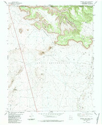
1983 Map of Skinney Rock
USGS Topo · Published 1984About this map
Industrial energy extraction and tribal lands meet in this high-desert landscape, where the Navajo Indian Reservation spans the south and the Ute Mountain Colorado Indian Reservation occupies the north. The terrain is defined by a series of prominent mesas and volcanic features, including Flat Top Rock, Blue Hill, and the map's namesake, Skinney Rock. This era of the late 1970s and early 1980s reveals a region heavily marked by petroleum exploration, with dense networks of drill holes and oil wells concentrated in the Horseshoe Gallup Oil Field and the Weekley Canyon Oil Field. Water remains a vital but sparse resource, managed through features like the Hogback Canal and the Aqueduct, while natural drainage flows through the Yellow Arroyo and Salt Creek Wash towards the San Juan Basin.
Find a feature on this map
24 named features on this map. Tap any name to fly to it.
Don’t see what you’re looking for? This feature index may not catch every label — zoom into the map to look around manually.
Map Details
Editions of this 1983 Skinney Rock Map
This is the sole edition of this map. No revisions or reprints were ever made.
Other maps of this area

1889 · Chaco
USGS Topo · 1:250,000

1892 · Chaco
USGS Topo · 1:250,000

1934 · Chimney Rock
USGS Topo · 1:62,500

1934 · Rattlesnake
USGS Topo · 1:62,500

1936 · Chimney Rock
USGS Topo · 1:62,500

1937 · Rattlesnake
USGS Topo · 1:62,500

1954 · Shiprock
USGS Topo · 1:250,000

1956 · Cortez
USGS Topo · 1:250,000

1958 · Cortez
USGS Topo · 1:250,000

1958 · Shiprock
USGS Topo · 1:250,000