
1985 Map of Skowhegan
USGS Topo · Published 1986About this map
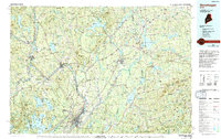
The Kennebec River corridor defines the industrial and agricultural landscape of central Maine in this mid-1980s planimetric study. Heavy settlement is concentrated at the river's falls and bends, most notably in Waterville, Winslow, and Skowhegan. These centers are linked by the Maine Central Railroad, which tracks alongside the water through Fairfield and Clinton, while the Bangor and Aroostook Railroad branches eastward toward Newport and Corinna.
Find a feature on this map
130 named features on this map. Tap any name to fly to it.
Don’t see what you’re looking for? This feature index may not catch every label — zoom into the map to look around manually.
Map Details
Editions of this 1985 Skowhegan Map
2 editions found
Other maps of this area

1892 · Waterville
USGS Topo · 1:62,500

1892 · Augusta
USGS Topo · 1:62,500

1893 · Vassalboro
USGS Topo · 1:62,500

1894 · Norridgewock
USGS Topo · 1:62,500

1898 · Norridgewock
USGS Topo · 1:62,500

1898 · Vassalboro
USGS Topo · 1:62,500

1900 · Bucksport
USGS Topo · 1:62,500

1902 · Bucksport
USGS Topo · 1:62,500

1902 · Bangor
USGS Topo · 1:62,500

1902 · Castine
USGS Topo · 1:62,500