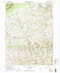
1965 Map of Slatedale
USGS Topo · Published 1984About this map
Slatedale and the surrounding Lehigh County townships of Heidelberg and Lowhill showcase a landscape defined by traditional Pennsylvania German settlement patterns and industrial extraction. The northeastern corner is heavily marked by Quarries near Emerald and Rextown, a legacy of the region's prominent slate industry. To the south and west, the terrain shifts into a series of ridges and valleys drained by Jordan Creek and Switzer Creek, where small hamlets like Germansville, Saegersville, and Lyon Valley are connected by winding country roads. The survival of several rural houses of worship, such as Heidelberg Ch and Lowhill Ch, alongside family-named landmarks like Werleys Corner and Millers Cem, provides a clear view of the area's mid-20th-century social geography. Public lands including State Game Lands No 217 along Blue Mtn and the Trexler Game Preserve preserve significant open space amidst the shifting agricultural and industrial zones.
Find a feature on this map
56 named features on this map. Tap any name to fly to it.
Don’t see what you’re looking for? This feature index may not catch every label — zoom into the map to look around manually.
Map Details
Editions of this 1965 Slatedale Map
4 editions found
Other maps of this area

1889 · Hazleton
USGS Topo · 1:62,500

1891 · Hazleton
USGS Topo · 1:62,500

1893 · Hazleton
USGS Topo · 1:62,500

1902 · Slatington
USGS Topo · 1:62,500

1909 · Hamburg
USGS Topo · 1:62,500

1911 · Hamburg
USGS Topo · 1:62,500

1922 · Mauch Chunk
USGS Topo · 1:62,500

1924 · Mauch Chunk
USGS Topo · 1:62,500

1937 · Allentown West
USGS Topo · 1:48,000

1942 · Allentown West
USGS Topo · 1:62,500
Featured Places
- Weisenberg Township, PA
- Lowhill Township, PA
- Werleys Corner, Weisenberg Township
- Lehigh Furnace, Washington Township
- Heidelberg Township, PA