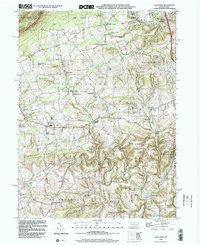
1999 Map of Slatedale
USGS Topo · Published 2002About this map
Blue Mountain and the ridge-top Appalachian Trail dominate the northern horizon of this Lehigh County landscape. Below the slopes, the topography reveals a transition from the industrial legacy of quarries near Slatedale and Emerald to the agricultural valleys of Heidelberg, Lynn, and Lowhill. The map preserves the names of numerous nineteenth-century rural centers, including Lehigh Furnace and Germansville, alongside established community hubs like Heidelberg Ch and Lowhill Ch. The drainage patterns of Jordan Creek and Trout Creek define the movement through these ridges, while the southern portion of the sheet is marked by the expansive Trexler Game Preserve and State Game Lands No 205. This layout reflects a century of land use, where slate extraction in the north gave way to conservation and traditional township settlements that remain anchored by local landmarks such as Werleys Corner and Newside.
Find a feature on this map
56 named features on this map. Tap any name to fly to it.
Don’t see what you’re looking for? This feature index may not catch every label — zoom into the map to look around manually.
Map Details
Editions of this 1999 Slatedale Map
This is the sole edition of this map. No revisions or reprints were ever made.
Other maps of this area

1889 · Hazleton
USGS Topo · 1:62,500

1891 · Hazleton
USGS Topo · 1:62,500

1893 · Hazleton
USGS Topo · 1:62,500

1902 · Slatington
USGS Topo · 1:62,500

1909 · Hamburg
USGS Topo · 1:62,500

1911 · Hamburg
USGS Topo · 1:62,500

1922 · Mauch Chunk
USGS Topo · 1:62,500

1924 · Mauch Chunk
USGS Topo · 1:62,500

1937 · Allentown West
USGS Topo · 1:48,000

1942 · Allentown West
USGS Topo · 1:62,500
Featured Places
- Weisenberg Township, PA
- Lowhill Township, PA
- Werleys Corner, Weisenberg Township
- Lehigh Furnace, Washington Township
- Heidelberg Township, PA