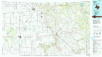
1986 Map of Slaton
USGS Topo · Published 1993About this map
Slaton and the high plains of the Llano Estacado define this mid-1980s landscape, where the transition from flat cotton fields to the erosional breaks of the Caprock is clearly visible. The Santa Fe railroad cuts a diagonal path across the grid, connecting regional hubs like Tahoka and Lubbock to the smaller siding settlements of Southland and Wilson. This era shows the extensive agricultural and industrial footprint of the region, specifically noted by the vast PHD Oil Field and numerous smaller oil operations scattered across the plateau.
Find a feature on this map
66 named features on this map. Tap any name to fly to it.
Don’t see what you’re looking for? This feature index may not catch every label — zoom into the map to look around manually.
Map Details
Editions of this 1986 Slaton Map
2 editions found
Other maps of this area

1954 · Lubbock
USGS Topo · 1:250,000

1954 · Hobbs
USGS Topo · 1:250,000

1954 · Big Spring
USGS Topo · 1:250,000

1954 · Brownfield
USGS Topo · 1:250,000

1957 · Lubbock East
USGS Topo · 1:24,000

1957 · New Home
USGS Topo · 1:62,500

1957 · Lubbock West
USGS Topo · 1:24,000

1957 · Lubbock
USGS Topo · 1:62,500

1957 · Meadow
USGS Topo · 1:62,500

1957 · Wolfforth
USGS Topo · 1:62,500