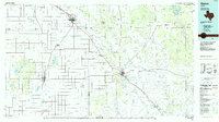
1986 Map of Slaton
USGS Topo · Published 1986About this map
Yellow House Canyon and the Cap Rock escarpment dominate this mid-1980s landscape, where the High Plains of the Llano Estacado drop away toward the Rolling Plains. The agricultural grid is punctuated by established settlements like Slaton and Tahoka, while the Atchison Topeka and Santa Fe railroad line serves as a primary transit corridor connecting Post to the larger hub of Lubbock. The map illustrates a complex network of water features including the White River Reservoir and the various forks of the Brazos River, such as the Double Mountain Fork Brazos River. This planimetric study reveals the transition from flat cotton-growing tablelands to the more dissected terrain of The Bedlands, providing a clear look at how topography dictated the placement of rural communities like Southland and Justiceburg.
Find a feature on this map
72 named features on this map. Tap any name to fly to it.
Don’t see what you’re looking for? This feature index may not catch every label — zoom into the map to look around manually.
Map Details
Editions of this 1986 Slaton Map
2 editions found
Other maps of this area

1954 · Lubbock
USGS Topo · 1:250,000

1954 · Hobbs
USGS Topo · 1:250,000

1954 · Big Spring
USGS Topo · 1:250,000

1954 · Brownfield
USGS Topo · 1:250,000

1957 · Lubbock East
USGS Topo · 1:24,000

1957 · New Home
USGS Topo · 1:62,500

1957 · Lubbock West
USGS Topo · 1:24,000

1957 · Lubbock
USGS Topo · 1:62,500

1957 · Meadow
USGS Topo · 1:62,500

1957 · Wolfforth
USGS Topo · 1:62,500