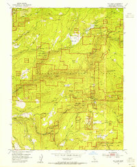
1953 Map of Sly Park
USGS Topo · Published 1954About this map
The Sly Park Reservoir basin is shown here in its final stage of preparation, with blue hatching indicating the exact area destined to be submerged upon the completion of the Sly Park Dam. This transition marks a significant shift for the Eldorado National Forest, as the landscape moved from a focus on timber and mining toward water management and recreation. The map captures remnants of the region's industrial past, including the Shippen Mill (Site) and numerous hard-rock operations such as the Hazel Creek Mine and Blue Gouge Mine.
Find a feature on this map
53 named features on this map. Tap any name to fly to it.
Don’t see what you’re looking for? This feature index may not catch every label — zoom into the map to look around manually.
Map Details
Editions of this 1953 Sly Park Map
This is the sole edition of this map. No revisions or reprints were ever made.
Other maps of this area

1889 · Pyramid Peak
USGS Topo · 1:125,000

1891 · Placerville
USGS Topo · 1:125,000

1891 · Pyramid Peak
USGS Topo · 1:125,000

1892 · Placerville
USGS Topo · 1:125,000

1893 · Placerville
USGS Topo · 1:125,000

1895 · Pyramid Peak
USGS Topo · 1:125,000

1896 · Pyramid Peak
USGS Topo · 1:125,000

1947 · Sacramento
USGS Topo · 1:250,000

1948 · Sacramento
USGS Topo · 1:250,000

1950 · Riverton
USGS Topo · 1:24,000