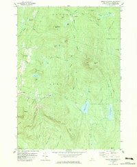
1979 Map of Smarts Mountain
USGS Topo · Published 1979About this map
Smarts Mtn anchors this section of the Grafton County highlands, where the Appalachian Trail winds past high-elevation landmarks like the Trapper John Shelter and a prominent Lookout Tower. The landscape is defined by its dramatic relief, spanning from the heights of Lambert Ridge and Moody Mtn down to a dense network of water bodies, including Reservoir Pond and the more remote Mud Turtle Pond.
Find a feature on this map
54 named features on this map. Tap any name to fly to it.
Don’t see what you’re looking for? This feature index may not catch every label — zoom into the map to look around manually.
Map Details
Editions of this 1979 Smarts Mountain Map
This is the sole edition of this map. No revisions or reprints were ever made.
Other maps of this area

1927 · Cardigan
USGS Topo · 1:62,500

1927 · Mascoma
USGS Topo · 1:62,500

1928 · Rumney
USGS Topo · 1:62,500

1930 · Cardigan
USGS Topo · 1:62,500

1931 · Mt. Cube
USGS Topo · 1:62,500

1932 · Mascoma
USGS Topo · 1:62,500

1932 · Rumney
USGS Topo · 1:62,500

1933 · Mt. Cube
USGS Topo · 1:62,500

1949 · Portland
USGS Topo · 1:250,000

1950 · Glens Falls
USGS Topo · 1:250,000