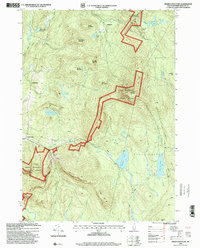
1996 Map of Smarts Mountain
USGS Topo · Published 2001About this map
White Mountain National Forest dominates the terrain of this mid-1990s survey, defined by the prominent peak of Smarts Mountain and the winding path of the Appalachian Scenic Trail. The landscape transitions from the developed slopes of the Dartmouth Skiway near Lyme Center to the more isolated upland basins containing Reservoir Pond and Cummins Pond. Local history is anchored in scattered settlements like Quinttown and family-named landmarks such as Demmick Hill, Cole Hill, and Winslow Ledge. The map captures the specialized recreational and forest-management character of the region, featuring a Ski Lift and hiker-specific infrastructure like the Trapper John Shelter. These details illustrate how the New Hampshire wilderness was utilized for both organized sport and quiet conservation at the close of the twentieth century.
Find a feature on this map
53 named features on this map. Tap any name to fly to it.
Don’t see what you’re looking for? This feature index may not catch every label — zoom into the map to look around manually.
Map Details
Editions of this 1996 Smarts Mountain Map
This is the sole edition of this map. No revisions or reprints were ever made.
Other maps of this area

1927 · Cardigan
USGS Topo · 1:62,500

1927 · Mascoma
USGS Topo · 1:62,500

1928 · Rumney
USGS Topo · 1:62,500

1930 · Cardigan
USGS Topo · 1:62,500

1931 · Mt. Cube
USGS Topo · 1:62,500

1932 · Mascoma
USGS Topo · 1:62,500

1932 · Rumney
USGS Topo · 1:62,500

1933 · Mt. Cube
USGS Topo · 1:62,500

1949 · Portland
USGS Topo · 1:250,000

1950 · Glens Falls
USGS Topo · 1:250,000