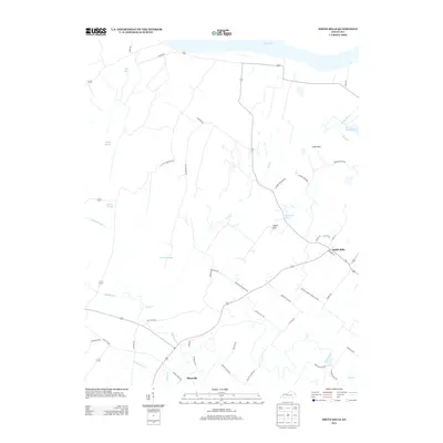
2013 Map of Smith Mills
USGS Topo · Published 2013About this map
Smith Mills and Hitesville anchor this riverine landscape in Henderson County, where the southern bank of the Ohio River defines the northern boundary. The terrain is characterized by a complex network of wetlands and seasonal watercourses, including Fishtrap Slough, Hogan Slough, and Hogland Slough. These hydrologic features suggest a history of floodplain management and agricultural adaptation common to the Ohio River valley. Moving inland, the topography rises into the Cabell Hills and Cape Hills, providing a contrast to the low-lying sloughs and the basin of Pond Cr. Local transit is defined by a web of rural routes like Baptist Church-Green Lick Rd and Old Kings Mill Rd, names that hint at the community's early social and industrial foundations. Small bodies of water such as Burbanks Lakes and Hardy Slough Pond are scattered across the quadrangle, punctuating the agricultural fields.
Find a feature on this map
51 named features on this map. Tap any name to fly to it.
Don’t see what you’re looking for? This feature index may not catch every label — zoom into the map to look around manually.
Map Details
Editions of this 2013 Smith Mills Map
This is the sole edition of this map. No revisions or reprints were ever made.
Other maps of this area

1906 · Sebree
USGS Topo · 1:62,500

1907 · Morganfield
USGS Topo · 1:62,500

1914 · Henderson
USGS Topo · 1:48,000

1916 · Henderson
USGS Topo · 1:62,500

1917 · Uniontown
USGS Topo · 1:62,500

1949 · Morganfield
USGS Topo · 1:24,000

1949 · Poole
USGS Topo · 1:24,000

1951 · Poole
USGS Topo · 1:24,000

1951 · Waverly
USGS Topo · 1:24,000
1951 · Morganfield
USGS Topo · 1:24,000