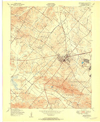
1951 Map of Morganfield
USGS Topo · Published 1951About this map
The sprawling Camp Breckinridge military installation dominates the southeastern portion of this 1951 survey, its boundaries and barracks infrastructure contrasting with the rural Union County landscape. The city of Morganfield serves as the regional hub, where the Illinois Central railroad lines converge near essential local services like the sewage disposal and filtration plant. Beyond the town center, the terrain is defined by the Chalybeate Ridge and the Dyer Hills, with numerous small family burial grounds such as Givens Cem and Rayburn Cem scattered across the countryside. An active Oil Field and proximity to agricultural settlements like Hamner and Harding reveal an era of diverse land use, where small country churches like Antioch Ch remained central to community life along the winding banks of Eagle Creek and Sibley Creek.
Find a feature on this map
36 named features on this map. Tap any name to fly to it.
Don’t see what you’re looking for? This feature index may not catch every label — zoom into the map to look around manually.
Map Details
Editions of this 1951 Morganfield Map
This is the sole edition of this map. No revisions or reprints were ever made.
Other maps of this area

1905 · New Haven
USGS Topo · 1:62,500

1906 · New Haven
USGS Topo · 1:62,500

1907 · Morganfield
USGS Topo · 1:62,500

1916 · Shawneetown
USGS Topo · 1:62,500

1917 · Uniontown
USGS Topo · 1:62,500

1949 · Paducah
USGS Topo · 1:250,000

1949 · New Haven
USGS Topo · 1:62,500

1949 · Morganfield
USGS Topo · 1:24,000

1950 · Paducah
USGS Topo · 1:250,000

1951 · Waverly
USGS Topo · 1:24,000