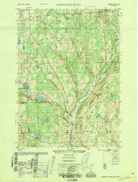
1950 Map of Smithville Flats
USGS Topo · Published 1950About this map
Genegantslet Creek winds through this central Chenango County landscape, anchoring the principal settlement at Smithville Flats. This 1950 record shows a rural economy defined by upland farming and local woodlots, with several outlying hamlets including McDonough and German Four Corners. The drainage patterns of the region are exceptionally clear, marked by a series of significant water bodies such as Long Pond, Echo Lake, and Cincinnatus Lake, many of which are surrounded by extensive wetlands like Brown Swamp and Witlow Swamp.
Find a feature on this map
49 named features on this map. Tap any name to fly to it.
Don’t see what you’re looking for? This feature index may not catch every label — zoom into the map to look around manually.
Map Details
Editions of this 1950 Smithville Flats Map
This is the sole edition of this map. No revisions or reprints were ever made.
Other maps of this area

1902 · Coventry
USGS Topo · 1:62,500

1903 · Norwich
USGS Topo · 1:62,500

1904 · Greene
USGS Topo · 1:62,500

1904 · Oxford
USGS Topo · 1:62,500

1904 · Pitcher
USGS Topo · 1:62,500

1943 · Cincinnatus
USGS Topo · 1:24,000

1943 · East Pharsalia
USGS Topo · 1:24,000

1943 · Pitcher
USGS Topo · 1:24,000
1943 · Norwich
USGS Topo · 1:62,500
1944 · Pitcher
USGS Topo · 1:31,680