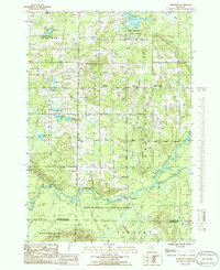
1985 Map of Smithville
USGS Topo · Published 1986About this map
Pere Marquette State Forest dominates this landscape in northern Michigan, where the Manistee River and Cannon Creek carve through the glacial terrain of Kalkaska and Missaukee Counties. The map documents a scattered network of small rural settlements including Smithville, Taffeltown, Millers Corners, and Giddings, many of which grew around early river crossings or timber operations. The presence of the Old RR Grade running through Orange and Boardman townships points to the region's historical reliance on rail for logging and transport. Local community life is anchored by the Gem Township Hall and various water bodies like Perch Lake and Sickle Lake, while industrial activity is noted at the Gravel Pits in the west. This survey provides a look at the transition between dense state forest land and the modest clearings of inland farmsteads in the mid-1980s.
Find a feature on this map
33 named features on this map. Tap any name to fly to it.
Don’t see what you’re looking for? This feature index may not catch every label — zoom into the map to look around manually.
Map Details
Editions of this 1985 Smithville Map
This is the sole edition of this map. No revisions or reprints were ever made.
Other maps of this area

1954 · Traverse City
USGS Topo · 1:250,000

1956 · Kalkaska
USGS Topo · 1:62,500

1956 · Fife Lake
USGS Topo · 1:62,500

1956 · Cadillac North
USGS Topo · 1:62,500

1956 · Lake City
USGS Topo · 1:62,500

1958 · Traverse City
USGS Topo · 1:250,000

1983 · Cadillac
USGS Topo · 1:100,000

1983 · Stittsville
USGS Topo · 1:24,000

1983 · Traverse City
USGS Topo · 1:100,000
1983 · Morey
USGS Topo · 1:25,000