
2000 Map of Smokemont
USGS Topo · Published 2001About this map
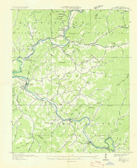
Smokemont and the community of Ravensford anchor this terrain where the Oconaluftee River meets the Raven Fork. This land is defined by the overlap of the Great Smoky Mountains National Park and the Cherokee Indian Reservation, showcasing a landscape of significant cultural and genealogical depth. The survey reveals a high concentration of family and community burial grounds, including Slave Cem, Nations Cem, and Mac Cem, many of which are tucked away on ridges like Hughes Ridge or along small tributaries.
Find a feature on this map
101 named features on this map. Tap any name to fly to it.
Don’t see what you’re looking for? This feature index may not catch every label — zoom into the map to look around manually.
Map Details
Editions of this 2000 Smokemont Map
This is the sole edition of this map. No revisions or reprints were ever made.
Other maps of this area

1891 · Cowee
USGS Topo · 1:125,000

1893 · Mt Guyot
USGS Topo · 1:125,000

1897 · Cowee
USGS Topo · 1:125,000

1907 · Cowee
USGS Topo · 1:125,000

1912 · Mt Guyot
USGS Topo · 1:125,000

1933 · Bryson
USGS Topo · 1:62,500

1935 · Addie
USGS Topo · 1:24,000

1936 · Bunches Bald
USGS Topo · 1:24,000
1936 · Whittier
USGS Topo · 1:24,000

1936 · Bryson
USGS Topo · 1:24,000
Featured Places
- Birdtown Community, NC
- Painttown Community, NC
- Ravensford, Yellowhill Community
- Wolftown Community, NC
- Big Cove, Big Cove Community